 The Itinerary
Spiti Valley in 8 days: Shimla to Manali the hard way
Eight days through Spiti the right way round — up from Shimla through Kinnaur so the altitude comes gradually, the 996 AD murals at Tabo, Key Monastery above the river, the world's highest post office at Hikkim, and out over Kunzum La past Chandratal to Manali.
- South Asia
- 8 days
- ≈ AED 1,700 / person
- A cold desert valley of 1,000-year-old monasteries, driven in the safe direction
Before you go
Eight days through Spiti is the best road trip in India, and the direction you drive it is a safety decision rather than a preference.
Go Shimla to Manali, not the other way. From Shimla the road climbs over five days through Kinnaur — 2,200m, then 2,800m, then 3,200m, then 3,800m — and your body keeps up. From Manali you cross Kunzum La at 4,590m on day one having slept at 2,050m, which is how people end up being driven back down at night.
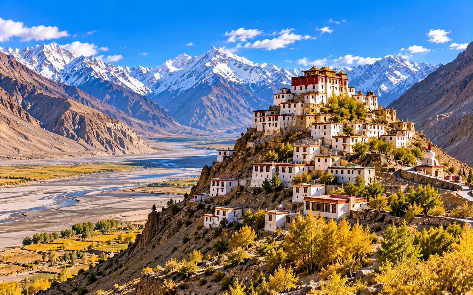
Spiti is a cold desert at 3,000–4,500m, Buddhist, Tibetan in culture and language, and almost entirely treeless. Tabo monastery was founded in 996 AD and its murals are sometimes called the Ajanta of the Himalaya. Key Monastery stacks up a conical hill above the river like something drawn rather than built.
Figure INR 44,000 (≈ AED 1,718) per person. June to September — this route only exists when Kunzum La is open.
Before you go: the season decides everything
- Kunzum La (4,590m) is usually open from June to October, and the Manali exit is impossible when it is shut.
- The Shimla–Kaza road stays open most of the year, so winter Spiti is reachable — as an out-and-back from Shimla, not a loop. That is an expedition, not this itinerary.
- July and August bring the monsoon to the Kinnaur side, and this is the stretch where landslides happen. The Spiti side is in rain shadow and stays dry.
- Mid-June and September are the sweet spots — passes open, monsoon not yet or already gone.
Before you go: altitude and permits
Altitude
- Kalpa 2,960m. Tabo 3,280m. Kaza 3,800m. Komic 4,587m. Chandratal 4,250m. Kunzum La 4,590m.
- The route is sequenced to climb gradually and that is its main virtue. Do not shortcut it.
- AMS — headache, nausea, breathlessness at rest, poor sleep — is common at Kaza and above.
- Descent is the treatment for anything worse. From Kaza that means hours of driving, so take symptoms seriously early.
- No alcohol above Kalpa, and drink far more water than feels necessary.
- Chandratal is the highest night and the one people struggle with. If you have had a bad day, skip it and drive through.
Permits
- Indian nationals need no permit for this route.
- Foreign nationals need an Inner Line Permit for the stretch near the Tibet border — between Rekong Peo and Kaza, via Sumdo. It is issued at Rekong Peo (or Shimla) in an hour, needs passport copies and photographs, and foreign nationals generally must apply in a group of two or more.
- OCI card holders count as foreign nationals.
- Carry several photocopies; checkposts keep them.
Flying in from the Gulf
- Fly to Delhi, then overland to Shimla — overnight train to Kalka and the UNESCO toy train up, or 8 hours by road.
- Out from Manali: the overnight Volvo to Delhi, or Bhuntar (KUU) if the weather cooperates.
- Leave a buffer day before an international connection. This road does not care about your flight.
Money and connectivity
- Carry cash — ₹20,000 for eight days. There is an ATM in Kaza and it is regularly empty or offline. Nothing else past Rekong Peo.
- Only BSNL postpaid works in most of Spiti, patchily. Assume no signal from Nako onwards.
Day by day
Day 1 — Shimla
- Arrive on the toy train if you can: five hours of narrow gauge through 102 tunnels, and the best approach in the Indian hills.
- 16:00 — The Ridge, the Mall and Christ Church.
- Sleep at 2,200m, which is the first step of the ladder — and the whole reason this route runs in this direction.
Day 2 — Up the Sutlej to Kalpa
- 06:30 — Leave early. Eight hours along the Sutlej gorge into Kinnaur, on a road cut into the cliff.
- 13:00 — Recong Peo for the Inner Line Permit if you are a foreign national. It takes about an hour; bring passport copies and photographs, and note foreign nationals generally need a group of two.
- 16:00 — Kalpa at 2,960m, in apple orchards, directly facing the Kinner Kailash range — a wall of rock and ice that catches the first light at dawn and is the reason to stop here.
- Early night, and be up for that first light.
Day 3 — Into Spiti: Nako and Tabo
- 07:30 — Leave Kalpa. The landscape changes at Spillow — trees stop, and the valley turns brown, grey and enormous.
- 11:00 — Nako at 3,660m, a village of mudbrick around a small lake, with a monastery holding 11th-century remains.
- 13:00 — The Sumdo checkpost, where permits are checked. Have the copies ready.
- 15:30 — Tabo at 3,280m, and the point of the day.
- 16:00 — Tabo Monastery, founded 996 AD, the oldest continuously functioning Buddhist monastery in India. The interior murals and stucco figures in the main hall are a thousand years old and survive because the building is mud, dark and dry. No photography inside; the lighting is deliberately minimal and a torch is handed to you. One of the great interiors in Asia, and almost nobody outside India has heard of it.
Day 4 — Dhankar, Pin Valley and up to Kaza
- 08:00 — Dhankar Monastery, perched on a crumbling spur between two valleys: the old capital of Spiti, visibly eroding, with a new monastery below because the old one is no longer safe.
- 09:30 — Dhankar Lake, an hour’s steep walk above it at 4,100m. Good acclimatisation if you are feeling strong — and a clear signal to slow down if you are not.
- 12:30 — The Pin Valley, a side valley and a national park: snow leopard country, though you will not see one in summer, and the only place in Spiti with much green.
- 17:00 — Kaza at 3,800m, the main town, such as it is. Take it easy on arrival — this is a significant step up, and the ATM here is regularly empty, so do not rely on it.
Day 5 — Key, Kibber and Chicham
- 06:30 — Key Monastery for morning prayers, 12km out: the largest in Spiti, founded in the 11th century and stacked up a conical hill in tiers. Sacked by Mongols, burned, and shaken by earthquakes — the shape is the result.
- 09:30 — Kibber at 4,270m, once billed as the highest village in the world connected by road, and the base for winter snow leopard expeditions.
- 11:00 — Chicham Bridge, Asia’s highest suspension bridge, across a gorge at 4,000m.
- 14:00 — Back in Kaza, and rest. You have been above 4,000m all morning.
Day 6 — The high villages
- 08:00 — Langza, with a large Buddha statue overlooking the valley and marine fossils in the ground from when this was the Tethys sea floor. Buy fossils from nobody — it is illegal and it is stripping the valley.
- 10:00 — Hikkim, with the world’s highest post office at 4,440m. Send a postcard; it takes weeks and it arrives.
- 11:30 — Komic at 4,587m, among the highest settlements in the world with a motorable road.
- Take all three slowly. You are above 4,400m for most of the morning, and this is the day people feel it.
- 15:00 — Back down to Kaza.
Day 7 — Kunzum La and Chandratal
- 08:00 — Kunzum La at 4,590m, the pass out of Spiti, with its chortens and prayer flags. Walk the circuit clockwise, as everyone does.
- 11:00 — Chandratal, the “moon lake”, at 4,250m, reached by a rough spur road and then a 15-minute walk. A crescent of blue in a bowl of scree, and one of the most beautiful places in the Himalaya.
- Camps sit 2–3km from the lake by regulation. You cannot sleep on the shore, and that rule is why the lake is still clean.
- It is cold: below freezing at night in August, no power beyond a generator hour, and no signal.
- If anyone has altitude symptoms, skip the camp and drive on down to Manali. That is the right call and it is not a failure.
Day 8 — Over Rohtang to Manali
- 07:00 — Down the Chandra valley to Gramphu. The Batal–Gramphu stretch is the worst road of the trip — river crossings, no surface, and slow. Four hours for 60km is normal.
- 12:00 — Gramphu, then either the Atal Tunnel or Rohtang Pass into Manali.
- 14:00 — Manali, and the sudden return of trees, oxygen and wifi.
- 16:00 — The overnight Volvo to Delhi, if you are going straight on.
Costs and practicalities
Best time to visit
- Mid-June to early July — passes newly open, the Kinnaur side not yet wet, and Spiti green by its own standards.
- September — the best month. Monsoon over on the Kinnaur side, passes still open, clear skies, and the light at its hardest and cleanest.
- July and August — the monsoon hits Kinnaur, not Spiti. The Spiti side stays dry and spectacular; the risk is entirely on the Shimla–Kalpa approach, where landslides close the road.
- October — beautiful, very cold, and Kunzum La can close without warning, stranding the Manali exit.
- November to May — the loop does not exist. Spiti is reachable from Shimla only, by a long, cold, frequently blocked road. Snow leopard trips to Kibber run in February, and they are serious undertakings.
Travel tips
- Shimla to Manali, never the reverse. This is the single most important line on the page.
- Confirm Kunzum La is open before you commit to the loop.
- Inner Line Permit at Rekong Peo for foreign nationals, with photocopies.
- Cash for eight days.
- No alcohol above Kalpa.
- A driver with Spiti experience and a high-clearance vehicle. This is not a hatchback road, and self-driving it without mountain experience is a bad idea.
- Carry a basic medical kit and know the descent route. The nearest real hospital to Kaza is a long way away.
- Carry out everything, including at Chandratal. There is no waste collection.
- Photography is banned inside Tabo’s old hall — respect it. Those murals are a thousand years old and light damages them.
- Do not buy fossils at Langza.
What this trip actually costs
Two people, 7 nights, mid-range comfort, international flights excluded:
| Item | Cost |
|---|---|
| Hotels and homestays, 7 nights, incl. a Chandratal camp | INR 28,000 (≈ AED 1,093) |
| Vehicle and experienced driver, 8 days | INR 40,000 (≈ AED 1,562) |
| Permits, monastery donations, entries, oxygen | INR 8,000 (≈ AED 312) |
| Food and drink, 8 days | INR 8,000 (≈ AED 312) |
| SIM, cash buffer, tips, extras | INR 4,000 (≈ AED 156) |
| Total for two | INR 88,000 (≈ AED 3,436) |
- Roughly INR 44,000 (≈ AED 1,718) per person, and the vehicle is nearly half of it. That is the correct shape for this trip: the road is the product, and the driver is a safety item.
- Accommodation is cheap and simple — homestays in Spiti run ₹1,500–2,500 with meals, and they are the best part of the trip. Stay in homestays wherever offered; the money goes directly into villages with very short earning seasons.
- Chandratal’s camps cost more than anywhere else for a tent at 4,250m.
- Shared transport exists — HRTC buses run Shimla–Kaza and Kaza–Manali — and will cut the transport line by 80% at the cost of all flexibility and most of the stops.
- Hotel picks here are chosen on location, not on commission — always check prices and recent reviews before booking.
What to pack
- A proper down jacket, even in August. Chandratal is below freezing at night.
- Thermals, hat, gloves, and layers for 25°C days and 0°C nights.
- High-factor sun cream and category 3–4 sunglasses. Thin air, no shade, and snow glare.
- A torch — for Tabo’s interior and for camps with generator hours.
- Lip balm and moisturiser; the air is extraordinarily dry.
- Cash, for the whole trip.
- A sleeping-bag liner for homestays and camps.
- Any altitude medication, discussed with a doctor first.
FAQ
Why Shimla to Manali and not the other way? Because the Shimla approach climbs over five days and the Manali approach throws you over a 4,590m pass on day one. Doing it in reverse is the most common cause of altitude trouble here.
Do I need a permit? Indian nationals, no. Foreign nationals and OCI holders need an Inner Line Permit for the Rekong Peo to Kaza stretch, issued in an hour at Rekong Peo, usually requiring a group of two.
Is the road dangerous? It is rough, narrow and exposed, and the Kinnaur section is landslide-prone in the monsoon. With an experienced driver and the right season it is a normal mountain road, not a stunt.
Can I do Spiti in less than eight days? You can drive it in five and you will spend the trip acclimatising badly. Eight is the sensible minimum for the full loop.
Is Chandratal worth the cold night? If the weather is clear and nobody is feeling the altitude, yes — the stars there are the best on this site. If anyone is unwell, drive on without hesitation.
Prices and entry rules change, and what you need depends on your passport; last checked 26 October 2026, so confirm with the embassy or your airline before booking.


