 The Itinerary
Southern Africa in 18 days: Cape Town, Sossusvlei, Etosha and the Okavango by road
Three countries in one vehicle: a city under a flat mountain, the highest dunes on earth, a salt pan you can see from space, and a delta that floods when Angola's rain arrives six months late — driven rather than flown, on gravel, with a rooftop tent.
- Southern Africa
- 18 days
- ≈ AED 20,200 / person
- The self-drive circuit, which is a different trip from a fly-in camp
Before you go
Before you go: the admin
Three countries, one vehicle, three sets of paper
- Most nationalities enter all three visa-free — South Africa, Namibia and Botswana each give 90 days.
- The vehicle paperwork is the real admin. You need a cross-border letter from the hire company, the registration papers, and a ZA sticker. Namibia and Botswana both charge a cross-border permit and road fund levy at the post, in cash.
- Botswana adds foot-and-mouth control: you drive through disinfectant and walk over a mat, and no raw meat or dairy crosses between some zones inside the country, let alone the border.
- Tell the hire company the countries when you book. Arriving at the desk and asking is how people lose a day.
Flights and the shape
- Fly into Cape Town and out of Maun, Kasane or Victoria Falls. A one-way vehicle drop is expensive but costs less than driving 2,000km back.
- Alternatively fly out of Windhoek and shorten the route to South Africa and Namibia only — a perfectly good 14-day version.
- The distances are the trip. Cape Town to Sossusvlei is 1,400km; Sossusvlei to Etosha another 800; Etosha to Maun 1,100. This is a driving holiday.
Money
- The South African rand is the reference currency. The Namibian dollar is pegged one-to-one and rand is legal tender in Namibia — though Namibian dollars are not accepted in South Africa, so spend them before you leave.
- Botswana’s pula is separate. Draw some at Maun or the border.
- Cards work in towns and at lodges. Fuel in remote Namibia and Botswana is frequently cash-only — this is the single most important cash rule on the route.
The driving brief
- Gravel is the hazard, not the animals. Namibia’s C and D roads are good gravel and the accidents happen at speed: keep to 80km/h, slow right down for corrugations, and never correct a slide sharply. Rollovers from oversteering are the most common serious accident here.
- Take the full tyre and windscreen waiver. Punctures are near-certain and the standard policy excludes both. Carry two spares.
- Do not drive at night, anywhere on this route.
- Fuel whenever you pass a station with supply, and carry 20 litres in a jerrycan north of Windhoek.
Day by day
Day 1 — Cape Town, the mountain
- 07:30 — Table Mountain by cableway, early — it closes for wind regularly and the queue after 9am is an hour. Check the website before leaving the hotel; they post the day’s status at seven.
- The Platteklip Gorge walk is the alternative and is two hard hours — straight up a cleft with no shade.
- 11:00 — The Company’s Garden, the Slave Lodge and the city centre on foot.
- 14:00 — Bo-Kaap, the painted houses and the Cape Malay quarter, with a cooking class if you book ahead.
- 16:00 — The District Six Museum, which is told by the people who were moved out of it.
- 19:00 — The V&A Waterfront or Bree Street for dinner.
Day 2 — Robben Island, and the townships
- 09:00 — Robben Island, booked ahead, with a former political prisoner as the guide. The ferry is cancelled for swell often — book the first sailing so a cancellation leaves you the afternoon.
- 13:00 — Lunch back at the waterfront.
- 15:00 — A township tour run from within the community rather than for it — ask who owns the operator, and Langa and Khayelitsha both have genuine ones.
- 18:30 — Signal Hill for sunset, and the noon gun fires from it daily if you are there earlier.
- Cape Town has real crime. Do not walk at night, do not display phones at junctions, and take advice locally about which beaches and paths are fine in daylight.
Day 3 — The Cape Peninsula
- 08:00 — The Cape Peninsula: Chapman’s Peak Drive, which is a toll road cut into the cliff and one of the great coastal drives.
- 10:30 — The Cape of Good Hope and the Cape Point funicular, with baboons at the car parks — they open car doors and they are not tame.
- 13:00 — The penguins at Boulders Beach, where the boardwalk keeps you off their nesting ground.
- 15:30 — Kirstenbosch, on the mountain’s other side, which is among the best botanic gardens anywhere.
- 18:00 — Back over Constantia Nek, with a wine estate on the way.
Day 4 — The Winelands, then east
- 09:00 — The Winelands — Stellenbosch and Franschhoek — as a day out, with a driver. The driver is not a luxury; the tastings are generous.
- The Franschhoek wine tram does the same job and nobody has to abstain.
- 15:00 — East toward Hermanus, about ninety minutes.
- 17:00 — Hermanus for the southern right whales, June to November, which are watched from the cliff path rather than a boat. The whale crier walks the path blowing a kelp horn when there are sightings.
- 19:30 — Dinner on the cliff.
Day 5 — Agulhas and the Garden Route
- 08:00 — Cape Agulhas, the actual southern tip of Africa, which is flatter and less dramatic than the Cape of Good Hope and is the real thing. The two oceans meet here, not at Cape Point.
- 11:00 — De Hoop, with the whale trail and the vlei, if you want the detour.
- 14:00 — East along the N2. Or Oudtshoorn and the Cango Caves inland if you want the Karoo instead of the coast — it is a different trip and both work.
- 17:00 — The Tsitsikamma and the Storms River suspension bridge, which is the end of the Garden Route proper.
- 19:00 — Overnight on the coast.
Day 6 — North to the border
- 06:00 — A long day up the N7 through Namaqualand. In August and September this is the wildflower bloom, which is one of the great floral displays on earth and is worth routing for.
- The flowers open to the sun and face it, so drive north in the morning with it behind you and they are open and pointing at you.
- 16:00 — Cross at Vioolsdrif / Noordoewer on the Orange River. Allow an hour and have the vehicle letter to hand — the rental company must supply a cross-border permit and without it you are turned back.
- 18:00 — Overnight on the river.
Day 7 — Fish River Canyon
- 06:00 — The main viewpoint and Hell’s Bend at sunrise or sunset, and sunrise is the better of the two.
- The second-largest canyon in the world — 160km long, 27km wide and 550m deep, and almost nobody there.
- The five-day hike is permit-only and runs May to September with a medical certificate. Day visitors see the rim.
- 11:00 — Drive the rim road between viewpoints, which most people skip.
- 15:00 — Ai-Ais hot springs at the southern end for the soak, which after the drive you will want.
- 19:00 — Fuel up. The distances from here north are long and the pumps are not.
Day 8 — To Sossusvlei
- 07:00 — A long drive north through the Namib-Naukluft, six to eight hours on gravel.
- Gravel driving is what rolls vehicles here. Keep under 80km/h, do not brake hard, and carry two spare tyres.
- 16:00 — Stay inside the park gate at Sesriem if you can — the inner gate opens an hour before the outer one, and that hour is the difference between Deadvlei in dawn light and Deadvlei with everyone else.
- 17:30 — Sesriem Canyon in the afternoon, a short walk into a slot in the rock.
- 21:00 — The stars after dark — the Namib is one of the darkest skies anywhere.
Day 9 — Sossusvlei
- 05:30 — Through the inner gate at first light.
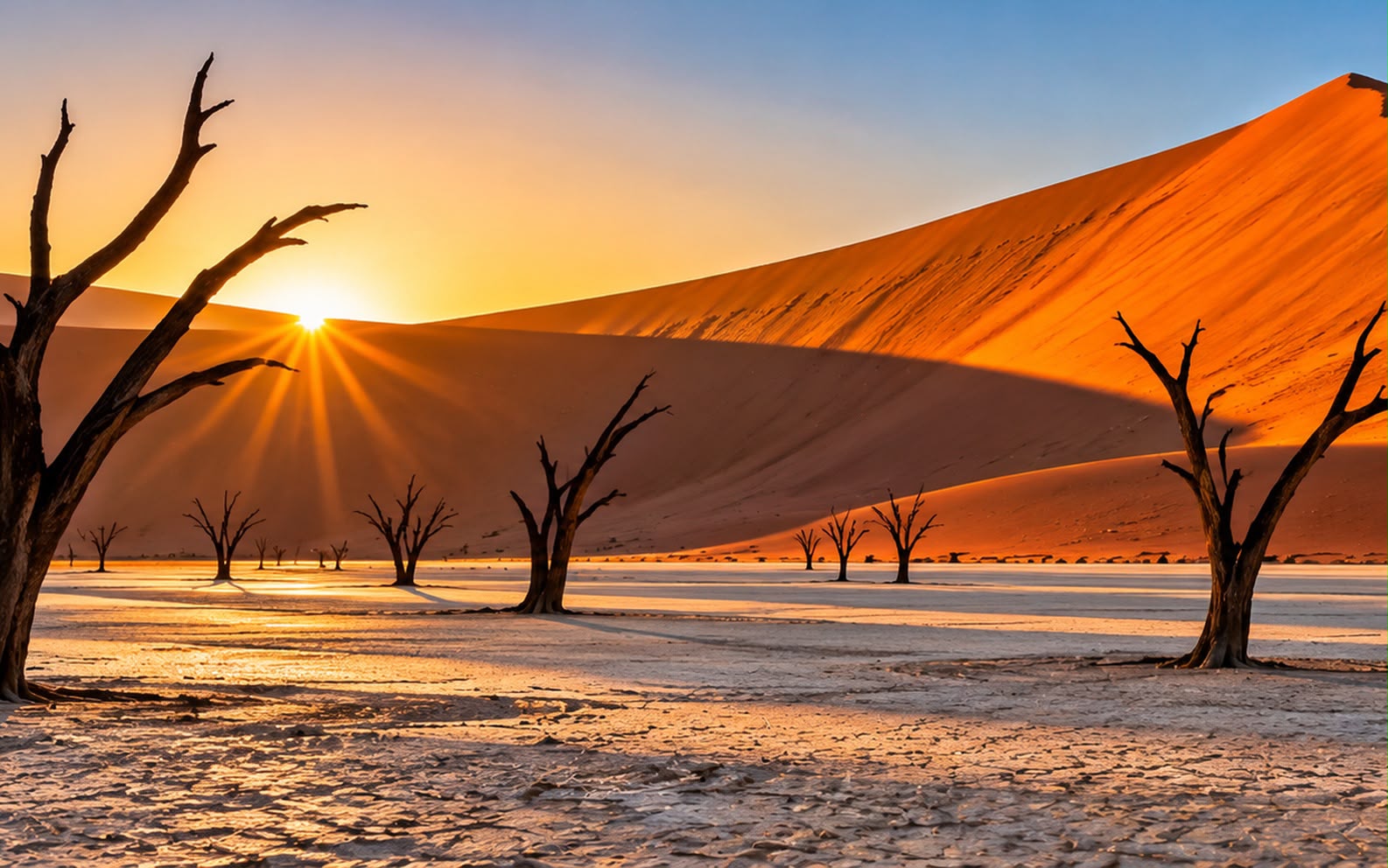
- 06:30 — Deadvlei is the photograph: 900-year-old dead camelthorns on a white clay pan against an orange dune. Go at first light. It is a 1km walk in soft sand from the 2x4 car park.
- 08:30 — Big Daddy and Dune 45 — the dunes here are among the highest on earth at over 300m, and the climb is in sand at a 30-degree angle. Dune 45 is the easier one and faces the right way at dawn.
- 11:00 — Out before the heat, which by midday is genuinely dangerous on the dunes.
- 16:00 — Elim Dune or the Sesriem viewpoint for sunset, both near the gate.
Day 10 — To Swakopmund
- 08:00 — The Kuiseb and the Gaub passes on the way, then the Atlantic appears out of nothing.
- 11:00 — Solitaire for the apple pie, which is a Namibia institution in the middle of nowhere.
- 14:00 — Walvis Bay lagoon for the flamingos on the way in.
- 16:00 — Swakopmund is improbably German — Bavarian architecture, Kaffee und Kuchen, and a cold grey sea at 15°C. The Benguela current is why.
- 19:00 — Dinner, and the seafood here is the best on the route.
Day 11 — Sandwich Harbour and the coast
- 08:00 — Sandwich Harbour by 4x4, where the dunes come down into the ocean, which is the best half-day in Namibia. It is tide-dependent and guide-only — you cannot drive it yourself.
- 14:00 — Cape Cross north for the fur seal colony — 100,000 animals and a smell you will not forget. Ninety minutes each way.
- Or quad bikes, sandboarding and skydiving if the adrenaline appeals; the Living Desert tour if the small things do — the latter finds sidewinders, geckos and chameleons in dunes that look empty.
- 18:30 — The jetty at sunset.
Day 12 — North to Etosha
- 07:00 — North via Spitzkoppe or the Erongo, which is granite inselbergs and San rock art.
- 10:00 — Spitzkoppe’s rock arch and the Bushman’s Paradise paintings, with a local guide from the gate.
- 15:00 — Then into the park — Anderson’s Gate in the south or Von Lindequist in the east.
- 17:00 — The first waterhole sit. Self-drive is excellent here — good gravel, clear maps, and you do not need a guide.
- 20:00 — The camp waterholes at Okaukuejo, Halali and Namutoni are floodlit and open all night, and this is the best game viewing in the park — sit and wait rather than drive. Okaukuejo’s is the famous one for black rhino after dark.
Day 13 — Etosha
- 05:30 — Out at gate opening, which is the best three hours of the day.
- Etosha is a salt pan 120km long, visible from space, and the game concentrates on waterholes around its edge because there is no other water.
- 11:00 — Back to camp through the heat, and the waterhole from a chair.
- 16:00 — The western waterholes — Okondeka for lion, Nebrownii for elephant.
- 21:00 — Okaukuejo after dark again, which rewards patience more than anything else here.
Day 14 — Etosha, east
- 05:30 — East toward Halali and Namutoni, stopping at every waterhole on the way.
- The dry season concentrates everything; in the green season the game disperses and the pan floods and fills with flamingo.
- 11:00 — Halali’s Moringa waterhole, which is the best of the three for rhino in daylight.
- 15:00 — Fort Namutoni, the white German fort, and the Fischer’s Pan loop.
- 19:00 — The last night in the park.
Day 15 — East to Botswana
- 07:00 — A long day across the Caprivi, or fly from Windhoek to Maun if the days are short.
- The Mohembo or Ngoma border, with the foot-and-mouth mats and the vehicle papers. No raw meat crosses, and the mats are not optional.
- 16:00 — The Okavango Panhandle at Shakawe, which is the self-driver’s delta — mokoro trips and fishing without the fly-in price.
- 18:00 — The river at sunset, with fish eagles.
Day 16 — The Okavango
- 06:00 — A mokoro day from the panhandle or Maun — poled through reed channels at water level, which is the way to see it. The poler stands behind you and the water is inches from your hands.
- The delta floods when Angolan highland rain arrives months later — so the water is highest in the dry season, which is the mechanism that makes this place work.
- 13:00 — A scenic flight over the delta is the cheaper alternative to a fly-in camp and shows you the shape of the thing — 45 minutes in a Cessna out of Maun.
- Moremi self-drive if your vehicle and nerve are up to it: deep sand, water crossings, and you need two vehicles and recovery gear to do it properly.
- 17:00 — A walk on an island with a guide, which the mokoro trips include.
Day 17 — Chobe
- 08:00 — North to Kasane, three hours on tar.
- Chobe has the highest elephant density in Africa and in the dry season they come to the river in their hundreds.
- 15:00 — Do the boat, not the game drive. The river cruise puts you at eye level with elephant, buffalo and hippo on the floodplain and is the better half of the day by a long way.
- 18:00 — Sunset on the river, which is the photograph from this leg.
- Victoria Falls is 80km away across the Zimbabwe border if you want to add it — a day trip is feasible and a night there is better.
Day 18 — Fly out of Kasane or Maun
- 08:00 — Drop the vehicle, which will be a different colour from when you collected it.
- Spend the pula and the Namibian dollars — neither is usable elsewhere. The Namibian dollar is pegged to the rand and rand are accepted in Namibia, but not the reverse.
- Leave margin. Regional connections from Kasane and Maun are limited and slip — and a missed connection here can cost a day rather than an hour.
Costs and practicalities
Best time to visit
May–October is the dry season and the only sensible window for a route built around game and gravel.
- May–August — dry, cool, and the best all-round. Nights are genuinely cold in the Namib and at Etosha, below freezing in June and July. The Okavango flood peaks around June to August, which is the counterintuitive part.
- September–October — hot and very dry, and the peak of waterhole concentration at Etosha and Chobe. October is punishing heat and the best game of the year.
- August–September — the Namaqualand wildflower bloom on the N7, which is worth routing the northbound leg for.
- November–April — the green season. Dramatic skies, excellent birding, newborn antelope, and rates fall sharply. Game disperses, the Etosha pan floods and fills with flamingo, and some gravel roads wash out.
- June–November — southern right whales at Hermanus, peaking September, which the Garden Route leg can be timed for.
Cape Town’s own best season is the opposite — November to March is its dry summer, which is why October is the best single compromise for the whole route.
Travel tips
- Tell the hire company all three countries when you book, and collect the cross-border letter, registration papers and ZA sticker. Without them you will be turned back.
- Keep to 80km/h on gravel and never correct a slide sharply. Rollovers from oversteering are the most common serious accident on this route, and they happen to confident drivers.
- Take the full tyre and windscreen waiver and carry two spares. Punctures are near-certain and both are excluded as standard.
- Fuel is cash-only in much of remote Namibia and Botswana. Carry rand and pula, and fill up at every station with supply north of Windhoek.
- Stay inside the Sesriem gate if Deadvlei at dawn matters — the inner gate opens an hour before the outer one.
- Sit at Etosha’s floodlit camp waterholes rather than driving around. Patience is what works in that park.
- Do not drive at night, and do not attempt Moremi’s sand and water crossings in a single vehicle.
What this trip actually costs
Two people, 17 nights, mid-range self-drive, international flights excluded:
| Item | Cost |
|---|---|
| Accommodation and camping, 17 nights | USD 3,400 (≈ AED 12,487) |
| 4x4 with rooftop tents, 16 days, cross-border | USD 2,600 (≈ AED 9,549) |
| Mokoro, Chobe cruise, Sandwich Harbour, Robben Island | USD 1,400 (≈ AED 5,142) |
| Food, drink and self-catering, 18 days | USD 1,000 (≈ AED 3,673) |
| Park fees and permits | USD 900 (≈ AED 3,305) |
| Fuel, border levies and road fund fees | USD 900 (≈ AED 3,305) |
| One-way vehicle drop or Windhoek–Maun flight | USD 800 (≈ AED 2,938) |
| Total for two | USD 11,000 (≈ AED 40,398) |
- Roughly USD 5,500 (≈ AED 20,199) per person. The vehicle and the fuel together are a third of it, which is the price of doing this by road rather than by light aircraft.
- A fly-in Okavango camp would add $1,400 per person for two nights and is the upgrade most people consider. It is a different trip, and the panhandle mokoro is the self-driver’s honest alternative.
- Ending at Windhoek instead of Chobe cuts about a quarter and four days, and is the sensible shorter version.
- Hotel picks here are chosen on location, not on commission — always check prices and recent reviews before booking.
What to pack
- A warm jacket and a hat. Namib and Etosha nights in June and July go below freezing, which surprises everyone packing for Africa.
- Dust protection for cameras — several blowers and more cloths than seems sane. The gravel gets into everything.
- Two headlamps and a decent torch for the camp waterholes.
- A 20-litre jerrycan and two spare tyres, which the hire company should supply and often does not without asking.
- Rand and pula in cash, enough for fuel between towns.
- Malaria prophylaxis for the Caprivi, Okavango and Chobe. The Namib, Etosha and the Cape are malaria-free, which matters if you are travelling with children.
- Reef shoes or sandals you can soak for the mokoro.
FAQ
Is self-drive really better than a fly-in safari? It is different, not better. A fly-in camp gives you the best guiding and the best game density for the money and none of the driving. Self-drive gives you Sossusvlei, the Skeleton Coast and Etosha’s waterholes, which no fly-in itinerary covers, at about half the cost per day.
Do I need a 4x4? For Sossusvlei’s last 5km, the Namib passes and anything in Botswana, yes. A 2WD with high clearance covers South Africa and most of Namibia’s graded gravel but will not get you into Moremi or Deadvlei.
How bad are the distances? Serious. Cape Town to Sossusvlei is two long days. This is a driving holiday with wildlife in it, and anyone who does not enjoy driving should fly the legs instead.
Can I add Victoria Falls? Yes — it is 80km from Kasane across the Zimbabwe border, and the KAZA UniVisa covers it. Two extra nights.
Is it safe? Yes, with ordinary urban caution in Cape Town and Johannesburg. The real risks here are gravel-road driving and dehydration, in that order.
Prices and entry rules change, and what you need depends on your passport; last checked 29 October 2026, so confirm with the embassy or your airline before booking.


